Darn, it's out of stock
(for now)
(for now)
Out of stock
Garmin Overlander GAR-010-02195-00-GOL GPS
is currently unavailable.
Often bought together
Everything you ever wanted to know about the Garmin Overlander GAR-010-02195-00-GOL GPS
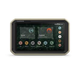
Garmin Overlander - Rugged Multipurpose Navigator for Off-Grid Guidance
On/Off Road
Garmin Explore
Find Campsites
Find Boundaries
Know Your Vehicle
RAM Mounted
InReach Compatible
BC™ 35 Compatible
Multi-GNSS Support
Product Features:
Built for every part of the journey, Overlander is a rugged, all-terrain navigator that can easily switch from turn-by-turn directions for on-road navigation to topography maps for off-grid guidance in North and South America.
On/Off Road
7” color touchscreen features turn-by-turn directions for on-road navigation and topography maps for off-road guidance covering North and South America.
Garmin Explore
Use the Garmin Explore app to download additional maps and USGS quad sheets on 64 GB of storage, and sync all of your data between devices (requires an active Wi-Fi connection).
Find Campsites
Preloaded with iOverlander™ points of interest (POIs) and Ultimate Public Campgrounds, so you don’t need a cell signal to find the best-established, wild and dispersed campsites.
Find Boundaries
Features topographic maps with public land boundaries and 4x4 roads.
Know Your Vehicle
Suggested routing is based on height, weight and length for large overlanding vehicles.
RAM Mounted
Can be mounted anywhere with a powered magnetic mount that comes with a suction cup or RAM-compatible adapter.
InReach Compatible
Pairs with inReach satellite communicators (sold separately; active satellite subscription required for inReach device) for two-way text messaging, interactive SOS and weather forecasts.
BC™ 35 Compatible
Pairs with up to four BC 35 backup cameras (sold separately) so you can see what’s behind you.
Multi-GNSS Support
GPS, GLONASS and Galileo support helps track in more challenging environments than GPS alone.
Product Features:
- 7” color touchscreen Features turn-by-turn directions for on-road navigation and topography maps for off-road guidance covering North and south America
- Use the Garmin explore app to download additional maps and usgs Quad sheets on 64 GB of storage, and sync all of your data between devices (Wi-Fi connection required)
- Preloaded with ioverlander points of interest (POIs) and ultimate public campgrounds, so you don't need a cell signal to route to the best-established, wild and dispersed campsites
- Features topographic maps with public land boundaries and 4x4 roads
- Routing is based on height, weight and length for large overlanding vehicles
- Can be mounted anywhere with a powered magnetic mount that comes with a suction cup or ram-compatible adapter
- Pairs with in reach satellite communicators (sold separately; active satellite subscription required for in reach Device) for two-way text messaging, interactive SOS and weather forecasts
- Pairs with up to four BC 35 backup cameras (sold separately) so you can see what’s behind you
- Gps, GLONASS and Galileo support helps track in more challenging environments than GPS alone
Garmin Overlander GAR-010-02195-00-GOL GPS
- Color : Black / Gold
- Model : Overlander GAR-010-02195-00-GOL
- Product type : Refurbished
- Brand : Garmin
- Weight : 15 oz
Welcome to Back Market
The best prices for high-quality reborn tech by sellers we’ve checked and vetted. We don’t mind if you Google us .
Get to know us


- Buy now, pay later.
- Free 30-day returns
- Free standard shipping
- 1-year warranty


1 - 3
- Current